


 Download(634.35KB)
 2.01
2.01
 1.2MB
1.2MB
Hi (gh) King - The GPS Tracker for Via Ferrata
Hi(gh)king is a GPS tracker that was developed with a focus on via ferrata tours at the Stuttgart Media University.
The following information is saved for a via ferrata tour:
- name
- Date
- List of data from the tour covered by the tour
- Length and latitude
- height over NN
- Date and time
- Photos that were taken during the tour.
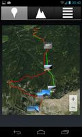
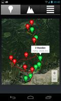
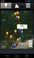
All recorded tours are archived and can be called up at any time:
- Presentation of the route covered on a satellite image, divided by back and forth
- Possibility to expand the route on the satellite image to expand time and distance points
- Presentation of the recorded images as thumbnails on the route covered and as a full screen
- Representation of the height profile
- Summary of the tour with data such as removal and rising/descending vertical meters, height difference and duration.
Extended map display: Images can be scolded, in addition it is possible to display distance and time brands (click on the map display for 3 seconds to activate)
Additional detailed information: start and end time as well as the deep and highest point of the tour are now also displayed
Improved representation of the height profile: zooming in the height profile is possible
Evaluation of the height information: Measurement errors are corrected
 Users also viewed
See all
Users also viewed
See all
updated
updated
updated
updated
updated
updated
updated
updated
updated
updated
updated
updated
Popular Games
See all
updated
updated
updated
updated
updated
updated
updated
updated
updated
updated
updated
updated